Climate Change: Northern Hemisphere’s summer of ‘global boiling’ - and what it means for NZ
The Northern Hemisphere’s “super-charged” summer - bringing heatwaves, floods and major wildfires across three continents - has already left hundreds of people dead, as records tumble each week and the UN’s chief warns of a new era of “global boiling”. Watching from Auckland is New York-raised National Institute of Water and Atmospheric Research (Niwa) meteorologist Ben Noll, who tells Jamie Morton what this all means for New Zealand’s coming El Nino summer.
We’ve seen some dramatic scenes playing out on the other side of the world, not to mention some dire new records being set. As a meteorologist from the US, what anomalies have been most striking to you?
The Northern Hemisphere’s summer is still ongoing, and so far, the regions with those striking anomalies have been outnumbering the ones without.
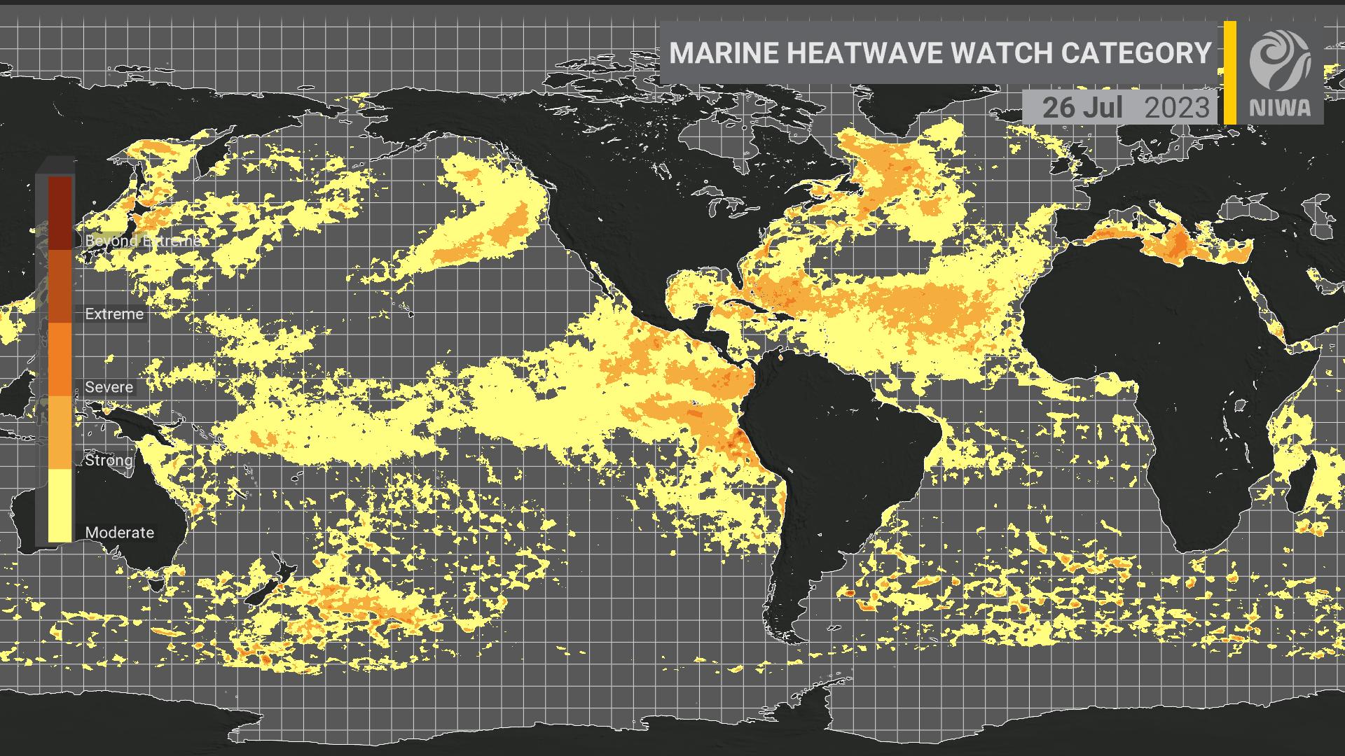
If we think about those marine heatwaves we’ve all grown accustomed to here in New Zealand, these are now being recorded near the coastlines of multiple continents - whether that’s eastern North America, western Europe or eastern Asia.
Last week, the Mediterranean Sea’s surface temperature reached a record 28.71C: the highest reading there since 2003.
Where we’ve had these really wild ocean temperatures, we’ve also been seeing dramatic flooding events and heatwaves on land.
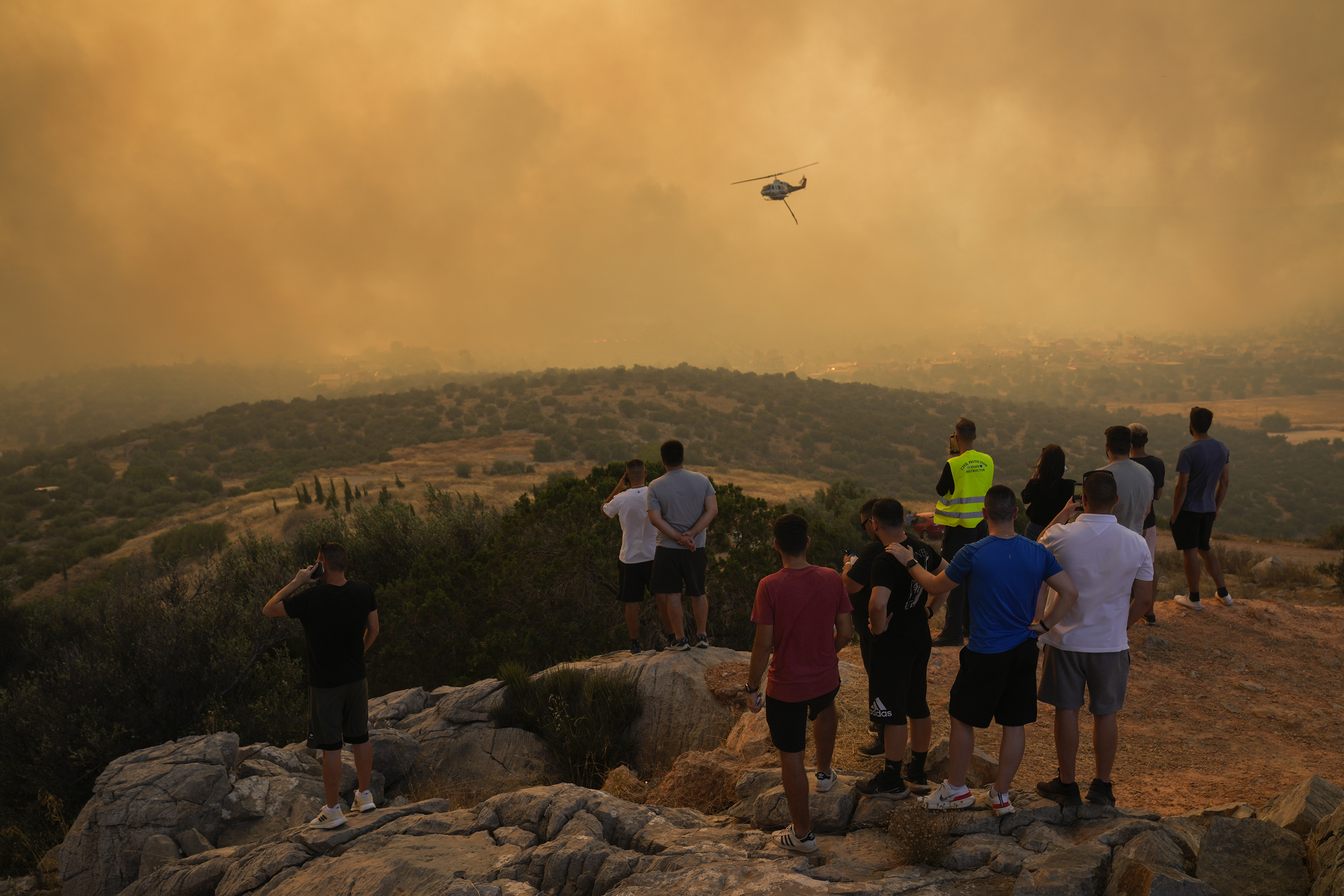
And anytime you have very hot temperatures on land, you’re going to have a drying of the ground and a higher rate of water evaporated, which helps to create conditions for sustained heatwaves and the kinds of wildfires we’ve been seeing in Sicily.
But week after week - or really, day after day - new temperature records are being broken across the hemisphere.
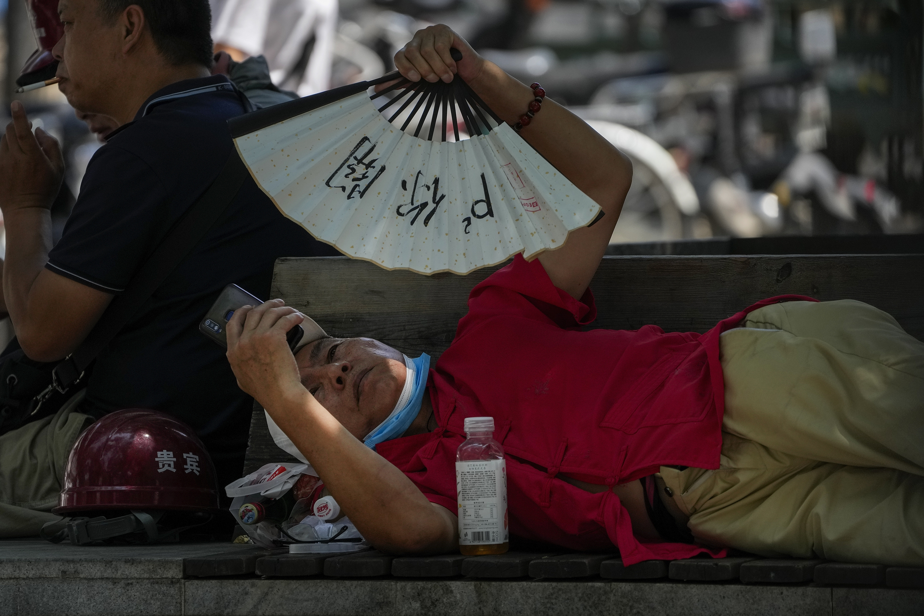
For instance, Phoenix, Arizona last week reached 47.7C, breaking a record that was set in 1989, and this month, nearly a third of the US has been under heatwave advisories.
Even overnight temperatures in parts of the US have been in the 30C to 35C range, so people aren’t even getting a break from the heat when they try to sleep.
Elsewhere, we’ve seen temperatures in parts of the Mediterranean climb into the 45C to 48C range, and China reportedly just set a new record of 52.2C, in Sanbao, only a few weeks ago.
Recently in Death Valley, California, where it was thought a reliable, all-time global temperature record might be about to be set, one person who was touring there died just a few hours after giving an interview about the extreme heat.
To me, though, it’s the prolonged nature of these temperatures, as well as the extremes, that is the really important thing.
And while we might be seeing readings in the late 40s and early 50s across the Northern Hemisphere right now, what happens in the future when we start nudging up above 55C across more widespread areas? And factor in the humidity, too.
Those types of temperature ranges are dangerous for humans.
What are the big drivers of this extreme northern summer?
I mentioned ocean heat content: we know that’s been increasing dramatically in recent decades as the ocean has collected excess heat and warmth, linked to the greenhouse effect.
Only, over time, it’s been losing its ability to balance the excess heat and prevent extreme temperatures on land.
This is an influence of climate change.
For instance, the World Weather Attribution group just reported climate change has made the European heatwave 2.5C hotter, and the North American heatwave 2C hotter.
These real-time studies are shedding light on the fact that, in a cooler climate, these heatwave events just wouldn’t have been possible.
Also in the background, we have a developing El Nino that’s typically associated with higher temperature extremes in the Northern Hemisphere.
Another driver is something called the Atlantic Multi-decadal Oscillation, or AMO.
When the AMO is in a positive phase, which it is now, it leads to warmer seas across the Atlantic basin, especially in the north - but a key question is, is the effect of the positive AMO being exacerbated by climate change and its influence on warming seas overall?
If this is what we’re seeing already, how dire might things get for the next northern summer, when El Nino is established?
Yes, this El Nino is still only in its formative stages, and we’re far from done with it.
Could the Northern Hemisphere get another summer dose of it? We can’t rule that out.
Generally speaking, El Nino’s impacts peak over the November to January period, but then there’s a lag that can sometimes stretch into the middle portion of the next calendar year.
This is because it takes a long time - months, or years in some cases - for the warmth that’s built near the equator to be redistributed back pole-ward.
That means there’s also a lag in potential extreme events that come with it, so it’ll be interesting to see what things look like one year from now.
People in New Zealand no doubt will have been watching news footage of these heatwaves and wondering what this El Nino means for our own coming summer. What can we say?
It’s important to stress that what we see in the Northern Hemisphere right now doesn’t mean any one thing for us here in New Zealand.
While we know the average outcome of El Nino, no El Nino is average - each event comes with a unique set of climate characteristics.
By the same token, however, I don’t think we’re looking at a rosy picture.
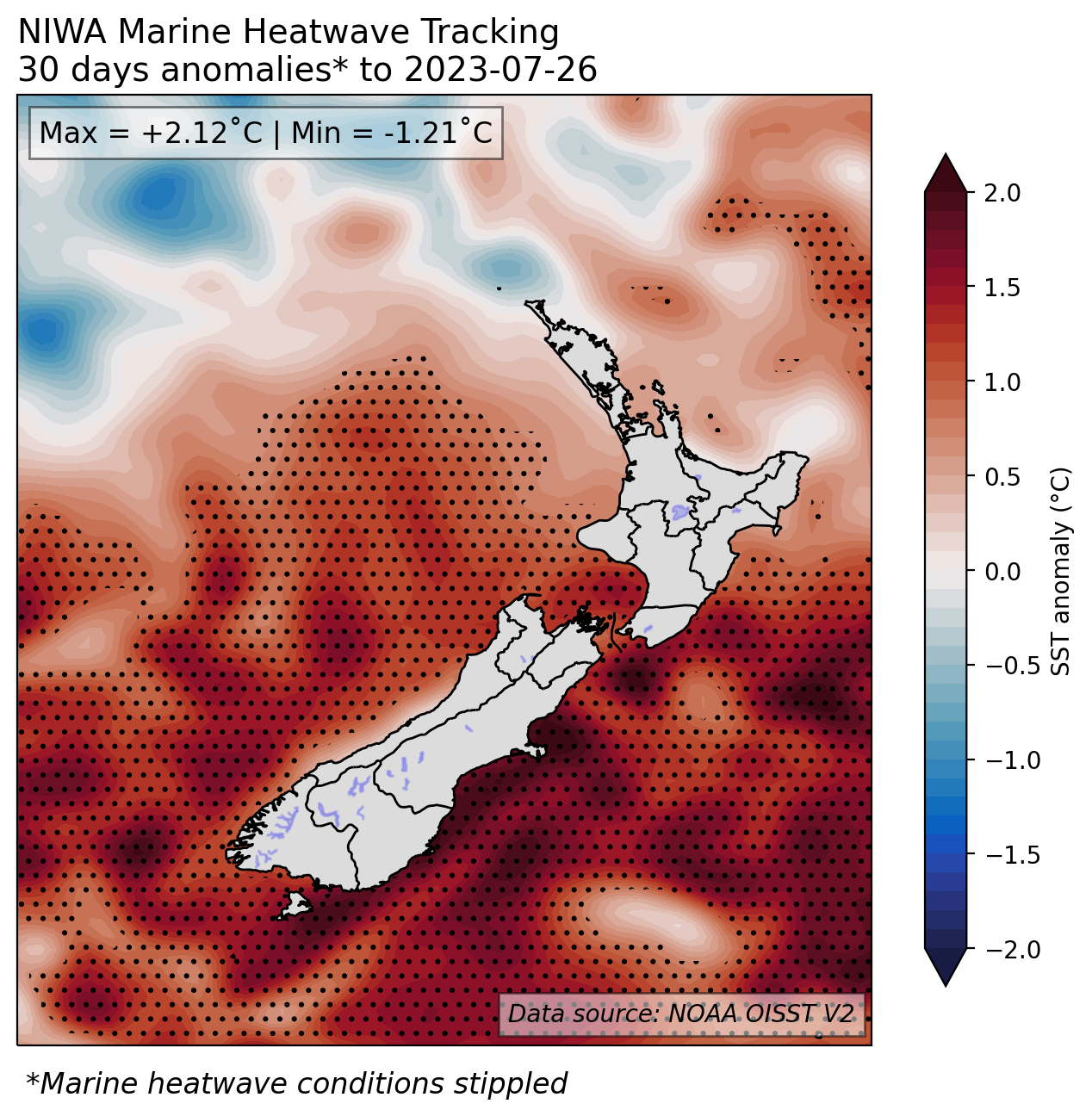
While we’re seeing these widespread extremes in the Northern Hemisphere, locally, coastal waters around the South Island and lower North Island are still in a marine heatwave state.
We also know El Nino tends to dry things out across in Australia - and we can often feel the effect of that here, in air masses that travel across the Tasman.
It’s also worth noting El Nino, coming after years of vegetation growth with La Nina, might well compound the threat of major bushfires in Australia - and it’s not out of the question that we’ll again see wildfire smoke in our skies.
Our idea of an extreme temperature in New Zealand is still the 42.4C reading that was recorded in Rangiora over the summer of 1972-73, and that happened to be an El Nino summer.
Again, this forming El Nino doesn’t guarantee that we’re in for our hottest summer ever, but, given the potential for it to bring more warm westerly winds and higher temperatures - especially along our east coast - it’s something to be aware of.
Perhaps, compared to what we’ve all experienced over our last two summers under La Nina, there’s potential for those daytime extremes to be bumped up a little higher.
What can we expect, at least for the next three months?
The strong southerly changes that have affected the country over the last week, we’ll have another one of those early in the first week of August. The second week of the month looks quite a bit drier than normal for wide swathes of the country as high pressure moves in from the Tasman Sea.
Later on in August, with the El Nino building, we can expect an increase in westerly winds for New Zealand - and with that warmth coming over the Tasman, later in the year, we might see 25C days arrive a little earlier than usual in eastern areas.
Because these westerlies will also be often stronger than normal, it might mean lots of moisture for the western South Island - and potentially other areas like Tasman and Taranaki.
Within our just-released seasonal climate outlook, we’ve indicated that high pressure may come to sit a little further north of the country, while lows might end up sitting closer to the South Island.
That means parts of the lower North Island, along with the western and lower South Island, may be more exposed to fronts and heavy rain events over the next three months.
On the flipside, we can say there’ll be decreasing chances for big moisture plumes and atmospheric rivers to reach the east of both islands, which should come as good news.
The region we’ve singled out as being the most likely to have below-normal rainfall is the northern North Island - or Northland, Auckland, Waikato, the Coromandel and the Bay of Plenty.
That’s something to note for farmers up north, who’ve had a very wet start to the year and now may see things start to dry out in the coming months.